We have a fairly standard (I think) Matomo deployment, and I’ve been looking at this documentation of displaying geographical information. As you might know, geographical boundaries can be quite contentious. Is it possible to get something like the city view (with circles indicating relative populations) at the worldwide level, and to then avoid drawing country boundaries as is done in the default map view in Matomo?
We’d like to avoid drawing country boundaries all together, if possible; it’s not just a matter of being able to draw a different set of boundaries.
Thanks for the detailed question, this is a good one. Here’s where things stand on both parts:
City-level bubble view (circles sized by visits/population)
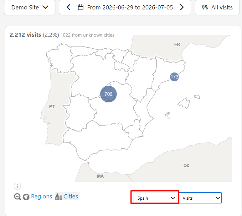
This is available natively in Matomo, but only once you’ve drilled into a specific country, not at the worldwide level. To reproduce it:
Go to Visitors > Locations
In the country dropdown below the map (it shows “Worldwide” by default), select a specific country
The “Cities” toggle (bottom-left of the map, next to “Regions”) becomes active, click it to switch to city bubbles for that country
At the worldwide zoom level, this toggle is disabled by design; Matomo’s map only exposes the city/bubble view per-country, not globally. So we can get you exactly this bubble style, just not with all countries showing at once out of the box.
Removing country boundaries entirely
This isn’t possible through any setting or configuration, at any zoom level. Matomo’s map (world, country, or city view) is drawn from a base vector file that has the country/region outlines built into it; there’s no toggle to turn that off.
What this means practically: getting both of your asks together (bubbles at world scale, with no boundaries at all) isn’t something we can turn on. It would need custom development, essentially building a standalone map widget using Matomo’s Reporting API to pull city-level visit data, rendered with a charting library so we have full control over the basemap (including leaving out political borders entirely).
Happy to scope that out for you if you’d like to go that route, or we can also just confirm the native per-country city view above meets your needs for now.
My hope is to be able to show a world map that shows some very rough geographical distribution of visitors, mostly to show off where in the world our users are coming from, but of course I want to avoid offending anybody with that map. The city bubbles are fantastic, but since I do want a world view it doesn’t quite work for me. I’m perfectly comfortable drawing my own world map, in fact, if I can extract all the data; maybe that’s the way to go? I see the Visitors Locations dashboard, and for example a list of cities; is that going to be inclusive, such that there are no “unknown” cities in the data and all visitors appear in that list somewhere?